


Manana Island Petroglyph
This article was originally printed in
The Maine Archaeological Society Bulletin, Vol. 44 (1) Spring 2004, pp. 15-20.
It has been reformat for this website.
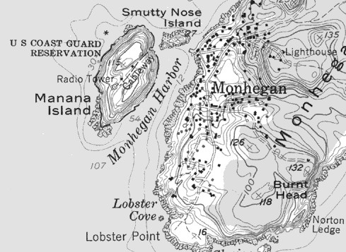 |
Fig. 1 – USGS Map – Monhegan (1979 Revision)
The Manana Island Petroglyph
By Mary Gage and James Gage
© 2004, Mary Gage and James Gage. All Rights Reserved.
Manana Island is located ten miles off the coast of south central Maine next to Monhegan Island (Fig, 1). It is approximately three quarters of a mile in length and half a mile wide. Access to the island is via a boat ramp (labeled “Cableway” on USGS map). A walkway climbs steeply from the boat ramp to a level section out to the light house on the west side of the island. The center of the island has a north and south rise of rocky ledge divided by a shallow dip in the ledge. At the west end of the walkway near the light house [Correction - it is a “fog signal station” not a light house], a ravine travels in a southwest direction from the center of the island to the ocean. Mid-way up the ravine on the north side is an outcrop. The south face of the outcrop is composed of rough surfaced medium gray rock with in intrusive vein of smooth surfaced whitish gray rock (Fig. 2). The vein of smooth whitish gray rock is approximately six to eight inches wide by three feet long. It is lined up on a left to right diagonal across the face of the outcrop. Across the complete length of this vein are a series of vertical and diagonal linear lines. The majority of the lines cross one or more adjacent lines. Most of the lines stay within the vein however a few extend beyond the edge.
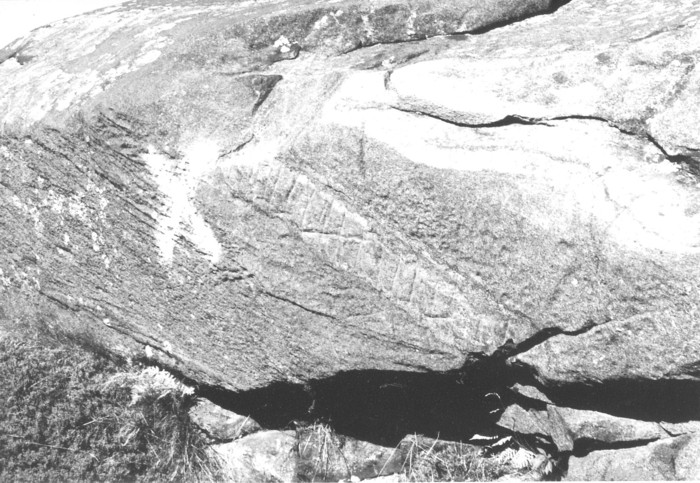 |
Fig. 2 – Photo of Outcrop (Photo by authors)
The first question one must address in evaluating this feature: Is it a petroglyph or the product of natural processes? The photograph clearly shows extensive natural ridges on the outcrop especially on the lower sections. The ridges are roughly parallel and delineate a series of layers in the outcrop. The lines in the vein of intrusive rock are for the most part perpendicular to the layering of the outcrop. Are the lines the product of glacial striations? According to Suzanne Wall, a professional geologist, “Glacial striations are shallow, linear and unidirectional.” (Wall 2003, 31) The lines in the vein are both vertical and diagonal and therefore are not unidirectional. In addition, glacial striations would not have been limited to a defined six inch vein rather they would be present across the whole rock face. Although extensively weathered, some of the lines show evidence of carving, specifically the presence of a V shaped groove. The evidence argues against the lines being the product of a natural process like glacial striations or natural layering of the rock. The multi-directional lines confined within a delineated space and showing evidence of carving is consistent with a man-made petroglyph.
Having established the feature as a petroglyph the remainder of this report will focus on the question of who carved it. The archaeological record of Monhegan Island (adjacent to Manana Island) indicates a long term Native American presence. Artifacts recovered from surface collecting, archaeological survey and excavations suggests that the island was used as a seasonal fishing camp during the following time periods 4,000 B.P. - 3,000 B.P. and 1,200 B.P. - 1,000 B.P. A copper spear point date circa 3800 B.P. from the great Lakes region and a hammer stone with a fossil from Nova Scotia, indicates that the Native Americans using the island had access to trade goods from outside of the Maine coast area (Bracy, personal communication, 2002).
The Manana Island Petroglyph embodies two distinct design elements. The first design element is a delineated space (in which the design is placed), in this case a vein of lighter colored rock on the outcrop. This delineated space is referred to hereafter as a band. The second design element is a grouping of closely spaced linear lines (vertical, diagonal, etc), the majority of which cross one or more adjacent linear lines. In the case of this petroglyph these two design elements are combined together. The authors conducted a detailed review of the archaeological record to determine if this combination of design elements was present in the Native American artistic traditions. The archaeological information from Monhegan Island provided a date range and geographical area for this review. The review covered the date range of circa 4,000 B.P. to contact period, and the geographical area of New England, New York state, and Southeastern Canada.
The review found that these design elements are present on numerous examples of Native American pottery and on some examples of portable rock art. With Native American pottery, the majority of design elements are confined within a band around the circumference of the vessels. Most of the elements are made up of vertical, horizontal, and diagonal lines. The lines were made by several techniques including punctate, dentate, trailing, or incised processes set in a linear pattern. Groupings of linear lines and linear line designs within bands are also found on some examples of portable rock art. Three examples are reviewed below.
 |
Fig. 3 – A. C. Hamlin’s Drawing of Manana Island Petroglyph (based on 1855 plaster cast) from Schoolcraft, History of the Indian Tribes of United States.
Holt’s Point Site, Bocabec, New Brunswick, Canada
Holt’s Point is on Passamaquoddy Bay on the southeastern tip of New Brunswick, Canada near the Maine border. The shell midden excavated in 1955 by the R. S. Peabody Foundation was dated to the Ceramic Period. Within the shell midden thirty six incised pebbles were recovered. An in-depth study by Dimity D. Hammon determined there were four groups of designs present on the pebbles. Groups 1 and 3 are triangular or pear shaped stones with tall arched band designs. Group 4 has left and right diagonal lines, some cross each other (Fig. 4) The example shown has two groups of lines. One group is vertical and the other is horizontal. One set of lines are long and stretch across the face of the pebble. There are no band elements in this group. Group 2 has rectangular shaped stones with horizontal bands of designs (Fig. 5). The example shown has four bands, top band on left side has a V and short vertical lines, right side has a row of two triangles one inside the other; second band has a row of triangles within triangles and short vertical lines between the tops of the triangles; third band has diagonal lines and opposing diagonal lines that cross each other; fourth band has single triangles and its whole area is filled with horizontal, vertical and left and right diagonal lines. Between each row is an incised line demarcating each band (Lenik 2002, 36).
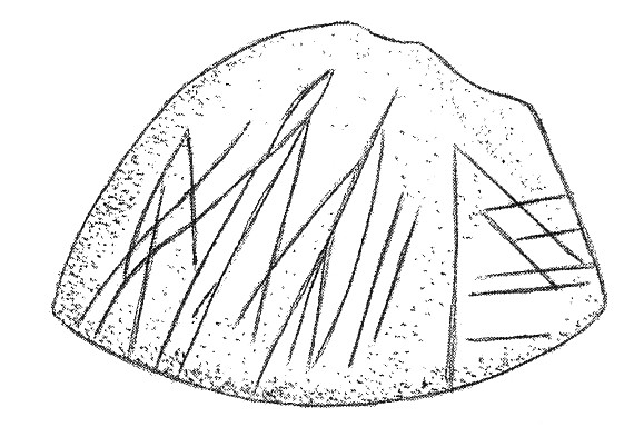 |
Fig. 4 – Holt’s Point: Portable Rock Art (Group 4 example). Drawing by T. Fitzpatrick from Lenik (2002), Picture Rocks: American Indian Rock Art in the Northeast Woodlands.
Reprinted with the permission of T. Fitzpatrick.
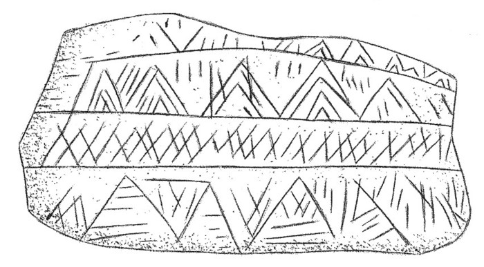 |
Fig. 5 – Holt’s Point: Portable Rock Art (Group 2 example). Drawing by T. Fitzpatrick from Lenik (2002), Picture Rocks: American Indian Rock Art in the Northeast Woodlands.
Reprinted with the permission of T. Fitzpatrick.
.Boucher Site, Vermont
The Boucher site in northwestern Vermont is dated to the Early Woodland period. Figure 6 shows a section of incised decoration from a nearly intact Vinette I pottery vessel excavated at the site. The decoration forms a wide band around the rim. On the section shown there are left diagonal lines, a few right diagonal lines and one complete triangle with three sides and another triangle formed by left and right diagonal lines that meet at the top with an open bottom (Haviland and Power 1994, 99).
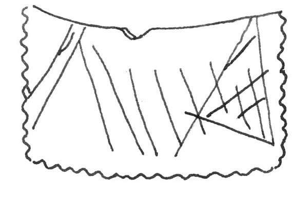
Fig. 6 – Boucher Site: Section of rare incised decoration on a Vinette I pottery vessel. Drawing by authors based upon photograph in Haviland and Power (1994), The Original Vermonters.
Southern New England
In the book, A Handbook of Indian Artifacts from Southern New England (Hoffman 1991) examples of pottery vessel design and artwork are shown but no specific locations are given. Under Middle Woodland Ceramics is a design called Trailing “Stage 2”. One of the examples shows a vessel with two wide bands with two different designs (Fig. 7). Starting at the rim is a narrow band with four short horizontal lines closely spaced, below is a wide band with sets of approximately four long vertical lines evenly spaced around the vessel, forming a demarcation line is another narrow band with short horizontal lines around the rim, below are opposing diagonal lines that cross each other, this pattern is set off by two closely spaced horizontal lines around the vessel, below are a few right and left diagonal lines filling in the base of the vessel. Note most of the diagonal lines are confined within the demarcated area but a few cross the horizontal lines (Hoffman 1991, 88).
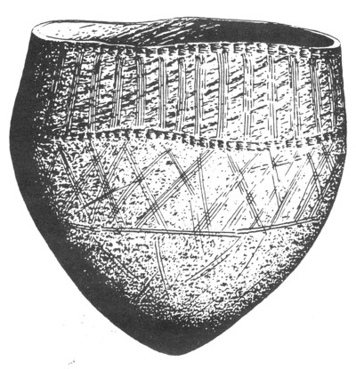 |
Fig. 7 – Southern New England: Example of Trailing “Stage 2” pottery with band decorations. From Hoffman (1991), A Handbook of Indian Artifacts from Southern New England.
Reprinted with the permission of Massachusetts Archaeological Society.
Conclusion
The Manana Island Petroglyph is composed of two design elements combined together: a group of closely space linear lines (many crossing adjacent lines) confined to a delineated band. Both of these design elements are found both individually and in combination on Native American pottery decorations and portable rock art. The archaeological record indicates a long term seasonal presence of Native Americans on the adjacent island of Monhegan. All of this evidence suggests that the Manana Island Petroglyph was carved by Native Americans. Like the Holt’s point incised pebbles, the purpose and meaning of the Manana Island Petroglyph remains enigmatic.
Bibliography
Bracy, Tralice
2002 Personal communication. Tralice Bracy is Curator of Monhegan Historical & Cultural Museum Association. The information provide came from the Museum’s records
Haviland, William A. & Power, Marjory W.
1994 The Original Vermonters: Native Inhabitants, Past and Present. Hanover, NH & London: University Press of New England
Hoffman, Curtiss R.
1991 A Handbook of Indian Artifacts from Southern New England. Middleborough, MA: Massachusetts Archaeological Society
Lenik, Edward J.
2002 Picture Rocks. Hanover, NH & London: University Press of New England
Wall, Suzanne
2003 Aboriginal Soapstone Workshops at Skug River II Site, Essex County, MA. Bulletin of the Massachusetts Archaeological Society, Vol. 63 No. 2 Fall 2003.
